The Challenge
Very few solar land parcels are perfectly flat with geometry that enables 100% “block” utilization. Grading them can create significant challenges and cost increases. Whether the challenge comes from an obstruction, a sloping hillside, a protected watershed, or another obstacle, these issues can hinder or stop projects. The large, rectangular “block” design of traditional tracking systems becomes impossible to lay out successfully.
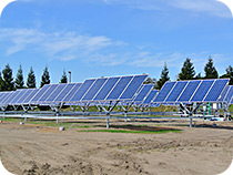
Benefits of the RTS
Design Flexibility
The design flexibility of the RTS enables system designers to maximize the use of their available space. If a project site has an obstruction, the trackers can simply be placed around the setback area. If a site has a slope or other terrain features, the trackers can be placed along the contours of the ground, preventing costly land grading and fully utilizing the available land. No system is as versatile as the Robotic Tracking System.
Increased yield
Regardless of the layout, the RTS will still provide optimized tracking, delivering up to 40% more energy than fixed-tilt and up to 15% more energy than single-axis tracking. Additional capacity enabled by the flexible RTS will further increase the project’s energy output and revenue.
Increased land suitability
By enabling tracking on sloped and custom areas, the RTS opens up new areas for development, such as paths along highways or triangular land sections near other developments. Additionally, the ability to use atypical solar sites enables the use of lower cost land.
Conclusion
The RTS enables new markets and projects, and the design flexibility enables maximizing system capacity. A custom parcel shape no longer means sacrifices in system power or system energy yield.